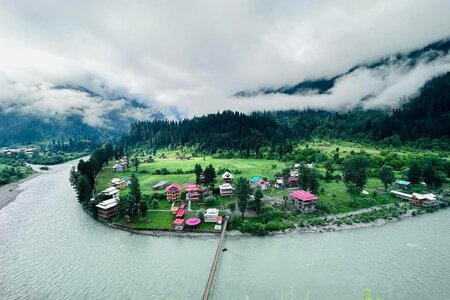
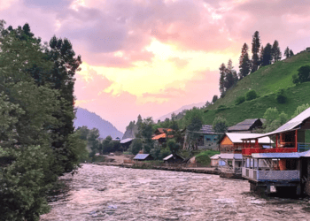

Chitta Katha Lake in Shounter Valley, near Kel, the second-to-last town in Azad Jammu and Kashmir. If you look for directions to Kel on Google Maps, it may suggest a route through Naran, and Jhalkhand. This route is incorrect. The only way to reach Kel by car is through Muzaffarabad, Keran, Sharda, and so on.
We left Islamabad for Kel on Thursday evening after work. We had a disappointing dinner at OPTP in Murree and then drove to Muzaffarabad. We reached Keran at 1 am and decided to stop for an overnight stay at a budget hotel.
We toyed with parking our car at Sharda and jumping on public transport, but the uncertainty of the next ride to Keran had us second-guessing. Plus, with Eid Day approaching, we were left wondering how we’d manage the return journey to Sharda amidst the celebrations.
Deciding to forge ahead, we pressed on and rolled into Kel around noon, a sense of adventure igniting our spirits. After spotting a perfect parking spot for our car, we eagerly inquired about the jeeps heading to Upper Domail, the gateway to the breathtaking Shounter Valley, where our trek awaited us. The excitement was palpable as we anticipated the stunning landscapes that lay ahead!
We managed to catch a public transport jeep that would take us to our destination. We, being frugal travelers, saved Rs. 400 by sitting on the roof instead of paying Rs. 400 for a seat inside.
However, the roof of the jeep turned out to be quite unpleasant. I assumed the locals were transporting live chickens to their villages for Eid feasts, and we were surrounded by cardboard boxes filled with them. There were also a few other passengers with us, along with their luggage. Our large rucksacks were piled up on the roof, leaving us no space for our legs. We had to awkwardly dangle them over the side of the jeep, which was uncomfortable due to a metal bar digging into the back of our knees.
We were confused about our destination. “Domail” and “Upper Domail” have different meanings in that area. In the end, we learned that we were going to a place called Houz. The jeep ride took just over two hours, during which we made numerous stops to let people on and off.
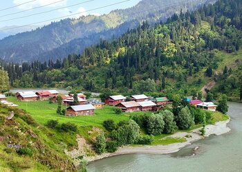
By the time we arrived in Houz in the evening, our journey on wheels came to an end. The distance from Islamabad to Chitta Katha Lake turned out to be about 330 km by road. In Houz, we found a campsite, a small masjid, and a guesthouse with a kitchen and a shop. We set up our tent just outside the guesthouse for the night.
The next morning, we awoke to the soothing sound of rain, a melody that signaled adventure. We had anticipated the arrival of rain during the monsoon season. With determination, we prepared for our hike and set out into the gentle downpour at around 7:00 am. We hired a guide, even though we had immersed ourselves in countless Chitta Katha Lake guide videos and meticulously studied the route maps on Google. From Houz, the main jeep path leads to Upper Domail, while a smaller trail descends into the enchanting path towards the lake.
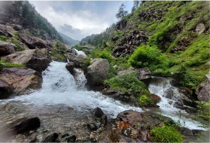
As we descended the winding trail, the soothing sound of Shounter Nala accompanied us, a picturesque river we had followed all the way from Kel. Before long, we found ourselves in a charming little village. The landscape was dotted with numerous trails, and we were grateful for our guide; his knowledge of the terrain ensured we found the right path through the winding alleys.
After navigating through the village’s quaint charm, we hit the trail leading us to the stunning Chitta Katha Lake. Just as we embarked on this next leg of our journey, the rain, a constant companion, finally ceased, leaving the air refreshingly crisp and invigorating.
We embarked on an exhilarating trek alongside the Chitta Katha Nala, famous for its stunningly white waters. We encountered a swirling mix of rich brown hues thanks to the rain. The trail wound close to the Nala, at one thrilling point merging directly with it, compelling us to navigate the edge of the rushing waters. The adventure escalated as we tackled a heart-pounding ascent, climbing up a steep slope that pulled us away from the Nala’s edge, promising new vistas and excitement with every step!
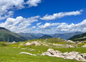
We eventually arrived at an expansive plateau from which the campsites of Dak-1 and Dak-2 were observable. Initially, we held the belief that these campsites were situated at a considerable distance from one another; however, we discovered that they are, in fact, merely a minute or so apart. I find it somewhat perplexing that they bear distinct names, given their proximity.
We took a break at Dak-2 to grab some snacks and ask for directions to our next stop. Most people usually camp at Dak-1 or Dak-2 before heading to the lake and returning the next day. Since it was around 10 in the morning when we arrived at the campsites, camping wasn’t an option for us. Our only choice was to go to the lake, which meant we would have to set up our camp by the water.
The locals at the campsite were not pleased with our plan to camp by the lake. They shared various cautionary tales to try and dissuade us, talking about unpredictable weather at the lake, people getting lost on the way back, and even stories about wild animals and supernatural beings (like Jinns!). They were very persuasive, making us wonder whether they were truly worried for our safety or just trying to keep us around for business since it was a peak holiday time. It’s worth noting that we were the only two people on the trail, which made their warnings even more concerning. If their stories were true, we might find ourselves in a tough situation, as no one else would be visiting Chitta Katha Lake during those days.
We took a break at Dak-2 to grab some snacks and ask for directions to our next stop. Most people usually camp at Dak-1 or Dak-2 before heading to the lake and returning the next day. Since it was around 10 in the morning when we arrived at the campsites, camping wasn’t an option for us. Our only choice was to go to the lake, which meant we would have to set up our camp by the water.
The locals at the campsite were unhappy with our plan to camp by the lake. They told us scary stories to try to change our minds. So, they warned us about the lake’s unpredictable weather, people getting lost, and wild animals and supernatural beings, like Jinns. They were convincing, made us wonder if they genuinely cared about our safety or if they wanted to keep us around for business since it was a busy holiday time. It was also worth noting that we were the only two people on the trail, which made their warnings even more concerning. If their stories were true, we could end up in a tough spot, with no one else visiting Chitta Katha Lake during those days.
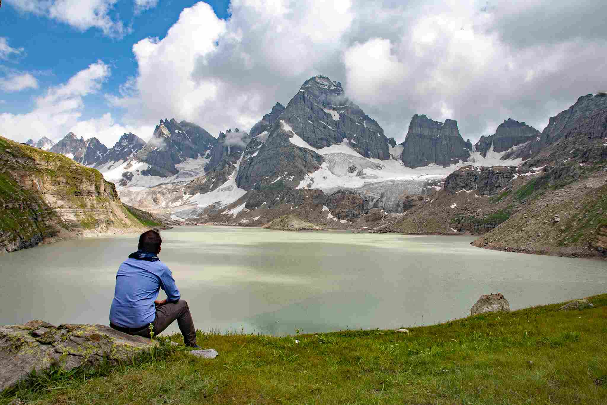
The clouds were low. Right in front of us was the Hari Parbat mountain. There were at least 3 waterfalls coming down from Hari Parbat and another 2 or so coming down from our right. The awe of that view can neither be described nor showed in any picture or video.
From this point onwards the grandeur of the hike to Chitta Katha became truly apparent. We crossed another bridge and proceeded forward.
We started our gradual ascent towards the right edge of the Hari Parbat. We got closer to the waterfalls and stopped many times to absorb the views around us.
The trail to the lake runs right next to the Hari Parbat waterfall, which is the farthest waterfall on the right side from Hari Parbat. Best part of the hike is the section where you walk towards the Hari Parbat waterfall, surrounded by red and blue flowers.
The fun times end here. Next comes a tough climb up the waterfall. You need to gain another 1 meter in altitude to reach a total of 1 meter above sea level. For comparison, this is like climbing the steep part of Islamabad’s Trail 3 or Trail 5 in just 0.5 km instead of 2.5 km, starting at 3,700 m ASL instead of 500 m ASL. This part of the climb is very steep and at a high altitude.
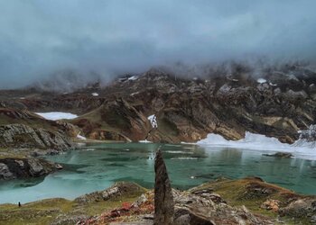
We took over an hour to climb 200 meters while covering 0.5 kilometers of the trek. We were almost at 4,000 meters, and the oxygen level dropped to 13%. This exertion and low oxygen level made me feel nauseous. Finally, the trail leveled out a bit. We were close to Chitta Katha Lake, and the peaks of the jagged mountains behind it started to appear. However, my need for a rest outweighed my motivation to reach the lake. My hiking buddy even fell asleep.
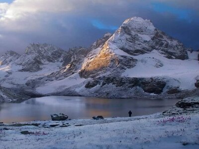
We continued for the final stretch. We crossed some patches of snow, and around 3 PM, we reached the beautiful and challenging Chitta Katha Lake.
The porters who came with us set up our camp and then left to return to Dak-2 before dark. I was very tired and felt unwell after the hike, so I didn’t take many pictures. Instead, I rested in the camp. After a while, just before sunset, I felt a little better, so I went out to enjoy the lake and take some pictures. I realized that this was the most amazing place I had ever camped.
As night fell, Chitta Katha Lake’s temperature dropped to below 10°C. We returned to our camp, cooked quick noodles on our portable stove, and enjoyed a delicious dinner, then went to sleep. In the middle of the night, I felt sick again. I jumped out of my sleeping bag and managed to get my head out of the tent just in time to throw up. Other than that, the night passed without any events. There were no wild animals and no strange happenings.
The next morning, we woke up early. The weather at Chitta Katha Lake had changed overnight. A thick fog covered the area, making it hard to see the lake. We had breakfast, packed our things, took one last look at the lake, and left. The fog was so thick that retracing our steps was a bit difficult. Still, we knew there was only one way down, and we found it fairly easily.
We went down to Dak-2 in just a few hours. It was Eid day, so we greeted the people at Dak-2, who were happy to see us. We gave them the leftover food since we didn’t need it anymore and continued our descent. The way down was tricky at times, especially near the steep area of Chitta Katha Nala.
We got back to Houz around midday. Because it was Eid, the usual transport to Kel wasn’t running. We waited for a few hours until we found a jeep going down. We got on and reached Kel by evening.
Chitta Katha Lake is, in my opinion, Kashmir’s second-best lake, but the hike to it is the best. The area is beautiful, with lush greenery, diverse plants and animals, waterfalls, and the lake itself. The trek is about 9 km long, even though some sources online say it’s longer. I know it’s 9 km because I tracked my hike using the Alltrails app both up and down. The challenge of this trek comes from its steep elevation gain of 1,260 meters over a short distance. I did some math and found that the average incline of the trek is 9°. I would gladly hike to Chitta Katha again if I had the chance, despite its challenge, because it’s worth it.


